
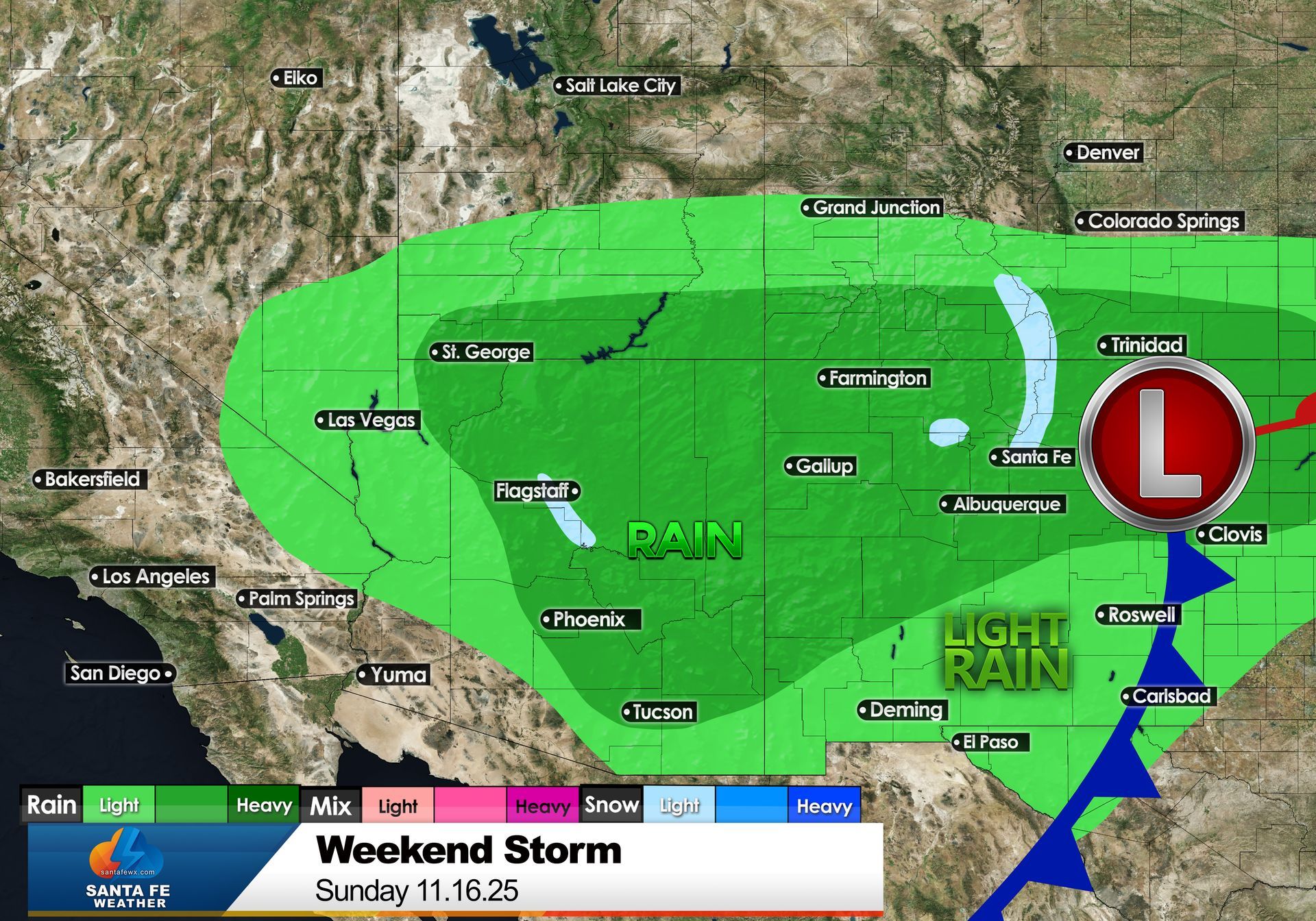
After weeks of sunny skies and mild afternoons, Santa Fe is on track for a pattern change this weekend as a Pacific storm system moves across New Mexico.
Wetter Weather Headed for Santa Fe. Will We See Our First Snowflakes of the Season?
Tuesday, November 11, 2025
By Jay Faught
After weeks of sunny skies and mild afternoons, Santa Fe is on track for a pattern change this weekend as a Pacific storm system moves across New Mexico. The result: cooler temperatures, increasing clouds, and a chance for much-needed precipitation. And yes — it could be just cold enough to bring the first snowflakes of the season to parts of town.
The week leading up to the storm looks mild and pleasant, with highs in the mid-60s and plenty of sunshine through Thursday. By Friday, high clouds will begin to increase as the leading edge of the system approaches. Saturday should feel noticeably cooler and cloudier, with highs in the upper 50s and a hint of moisture in the air. The bigger change arrives Sunday, when temperatures dip further — highs near 50°F and lows around freezing — and a few rounds of showers are expected.
At this point, the key question is whether those showers turn to snow. It’s certainly possible. Santa Fe’s elevation of about 7,000 feet often puts it right on the edge between rain and snow during early-season storms. The average date of the first measurable snowfall in town is November 14, so the timing of this weekend’s system lines up almost perfectly with our climatological norms.
During the day Sunday, most of the precipitation will likely fall as rain or a rain-snow mix, especially in the lower parts of the city where surface temperatures remain above freezing. However, as evening approaches and temperatures cool, some of that moisture could transition to snow — particularly on the north side of town, the foothills, and higher elevations toward Hyde Park and the ski basin. If the storm lingers into Sunday night, the first light dusting of snow in town becomes a real possibility.
At higher elevations in the Sangre de Cristo Mountains, snow is much more likely. The colder air aloft will support accumulation, and the peaks could easily pick up several inches of early-season snow. For skiers, hikers, and snow watchers, that’s a promising sign that winter may be waking up right on schedule.
Even if Santa Fe only sees a brief flirtation with snow, the moisture is welcome news. Autumn has been on the dry side, and a wet storm system helps moisten soils and replenish the high desert air. It also signals the seasonal transition — a reminder that in northern New Mexico, the weather can shift dramatically from warm and sunny to cool and damp in a matter of hours.
If you’re making weekend plans, Saturday looks to be the milder of the two days, with more clouds than rain. Sunday, however, will feel distinctly like November — cool, breezy, and possibly wet. If you’re traveling, especially into the foothills or mountain areas, watch for slick spots as temperatures drop near freezing Sunday night.
So, will we see our first snowflakes of the season? It’s certainly within reach. While a major accumulation in town is unlikely, a few flakes swirling through the evening air would be a fitting start to the colder season ahead. Keep your camera handy — the first snow of the season is always worth capturing.
Stay tuned for updates as the storm approaches. I’ll be tracking the latest forecasts and models right here on SantaFeWX.com, with new details on timing, snow potential, and travel impacts as the weekend unfolds.
Santa Fe Weather

The Albuquerque International Balloon Fiesta may look magical, but every launch depends on one thing: the wind.
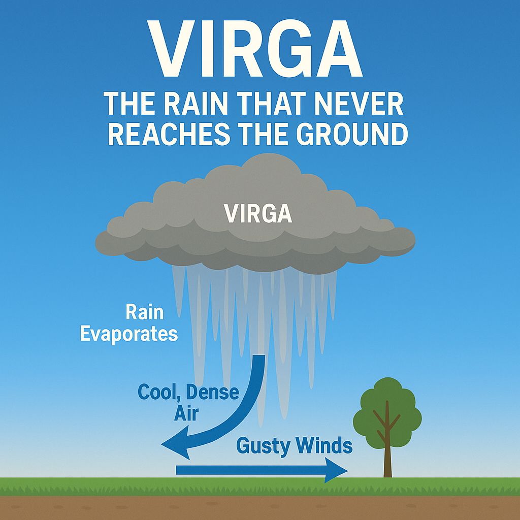
If you’ve lived in Santa Fe for any length of time, you’ve probably seen what looks like streaks of rain falling from clouds — but then you notice the ground stays bone dry. That phenomenon is called virga, and it’s a regular part of our weather here in northern New Mexico.

With it being so hot out this week, I can't think of a better time to talk about a winter snowfall forecast.

I dove into the data to find out if the frequency of tornadoes are actually increasing in Santa Fe County.

Santa Fe may not be a sprawling metropolis, but its unique topography gives it a surprising range of microclimates.
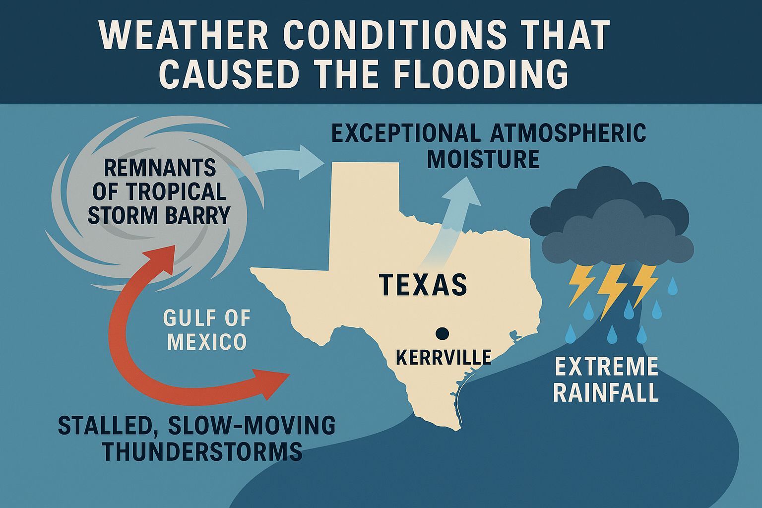
A rare combination of tropical moisture, stalled thunderstorms, and rugged Hill Country terrain created the perfect setup for catastrophe. I broke down the weather ingredients that led to this deadly flash flood.
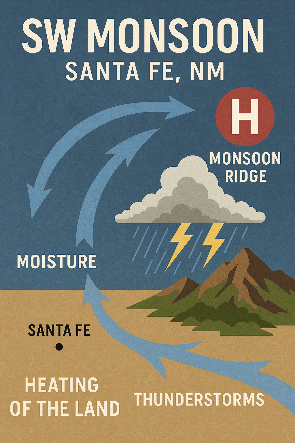
If you've been in Santa Fe for any period of time, you've already encountered the summer monsoon. But do you know what it really is and how much we depend on it?

On a personal note for this Father’s Day, I want to take a moment to recognize and honor my late father, Wendell Faught (1929–1998).

Your safety comes first, and I want to be sure you know where to turn during severe weather.

A dust devil is a small, rotating column of air that picks up dust, sand, and debris as it spins across the ground.