
A dust devil is a small, rotating column of air that picks up dust, sand, and debris as it spins across the ground.

Whirling Wonders of the Desert: Dust Devils
May 17, 2025
By Jay Faught
If you’ve spent any time in Santa Fe or the surrounding high desert, chances are you’ve spotted one of nature’s most mischievous little windstorms spinning its way across a dirt road, a construction site, or an open field. These swirling columns of dust and debris are called dust devils, and while they might look like mini-tornadoes, their origin and behavior are quite different—and fascinating.
What Exactly Is a Dust Devil?
A dust devil is a small, rotating column of air that picks up dust, sand, and debris as it spins across the ground. Unlike tornadoes, which are born from powerful thunderstorms and can be dangerous, dust devils form on clear, sunny days—and most are harmless. They typically last only a few seconds to a few minutes and are rarely more than a few dozen feet wide, though some can grow taller than a three-story building.
How Do They Form?
Dust devils form when strong surface heating creates an unstable atmosphere close to the ground. Here’s a step-by-step breakdown:
- The ground gets hot—especially in areas with little vegetation, like the arid landscapes around Santa Fe.
- The hot surface heats the air directly above it, creating a pocket of warm, low-density air.
- This warm air rises quickly through the cooler air above it, creating a small updraft.
- If there’s a slight horizontal wind or uneven heating of the ground, this rising air can start to rotate.
- As the spinning column pulls in more air, it picks up dust and debris, making the vortex visible.
Santa Fe’s high elevation, strong sun, dry soil, and wide-open spaces make it an ideal place for these whirlwinds to form—especially on spring and summer afternoons when the ground heats up quickly under the clear New Mexico sky.
Dust Devils vs. Tornadoes: What’s the Difference?
It’s easy to confuse a dust devil with a tornado at first glance, but the differences are significant:
- Dust devils form from the ground up on sunny days; tornadoes form from the sky down during thunderstorms.
- Dust devils are usually harmless, while tornadoes can be devastating.
- Tornadoes are part of a much larger storm system, while dust devils are localized phenomena.
Where Are Dust Devils Most Common?
Dust devils are most commonly found in desert and semi-arid regions around the world, including the American Southwest, northern Africa, Australia, and parts of Mars (yes—Mars!). In the U.S., they’re especially common in Arizona, New Mexico, Nevada, and parts of Texas and California.
Here in Santa Fe, they’re often spotted:
- In empty dirt lots or parking areas on the south side of town
- On the open stretches of the Turquoise Trail or U.S. 285
- Near construction sites where the soil has been disturbed
- Even in some backyards, especially if there’s loose dirt and strong sunshine
Santa Fe Weather

Understanding the 4 Monsoon Patterns That Bring Rain to Santa Fe

What is an outflow boundary and how is it different from a derecho?

A quick ENSO refresher and why this winter felt so different The El Niño–Southern Oscillation (ENSO) is a naturally recurring pattern of ocean temperature and atmospheric circulation changes over the tropical Pacific that can shift weather patterns far from the tropics, including across North America. El Niño is the warm phase (warmer-than-average sea surface temperatures in the central/eastern tropical Pacific), while La Niña is the cool phase (cooler-than-average sea surface temperatures there). Even though ENSO is a tropical phenomenon, it matters here because it can influence the position and strength of the jet stream and storm tracks that deliver (or miss) our precipitation—especially in the cool season. This past winter’s pattern was consistent with La Niña impacts in New Mexico, which often tilt the odds toward drier-than-normal cool seasons (winter into spring), while El Niño tends to tilt the odds wetter. In fact, New Mexico’s 2025–26 winter has been widely described as exceptionally warm and snow-starved at the statewide scale, with the National Weather Service in Albuquerque citing record-low mountain snowpack and well-above-normal temperatures. Locally, the story in Santa Fe has been the same theme: very limited snowfall in town and a slow start to spring moisture. In your local tally, Santa Fe has only picked up about 6.3” of snow so far this season, compared with about 22” in a “typical” winter. La Niña is fading: why we’re entering neutral now and what that usually implies for spring The latest official update from the NOAA Climate Prediction Center (issued March 12, 2026) indicates that La Niña is expected to transition to ENSO-neutral within about the next month, with ENSO-neutral favored through May–July 2026. That “neutral” label does not mean “normal weather.” It simply means the tropical Pacific is not strongly tugging the atmosphere toward either El Niño-like or La Niña-like patterns. When ENSO is neutral, other drivers—shorter-term Pacific variability, land-surface dryness, and regional circulation patterns—often have more influence, and predictability can drop. For northern New Mexico, the near-term baseline matters too: going into spring, the state has been dealing with record-low snowpack and very warm conditions, which can accelerate drying of soils and fuels and reinforce a warm, dry pattern locally. 62% chance of El Niño developing by early summer, with persistence likely Here’s the key forecast signal to watch. In the same March 12, 2026 diagnostic, the CPC states: El Niño is likely to emerge during June–August 2026, with a 62% chance, and if El Niño forms, it is expected to persist through at least the end of 2026. CPC also emphasizes that the strength of a potential El Niño remains uncertain. Still, their current guidance includes a notable risk tail: about a 1-in-3 chance the event could be “strong” by October–December 2026 (Niño-3.4 at or above +1.5°C). It’s worth highlighting what forecasters mean by “developing in time.” ENSO’s strongest and most reliable regional effects in the Southwest are typically in the cool season (late fall through spring), while the summer monsoon signal is weaker and more conditional. So for monsoon impacts, timing (how quickly the ocean–atmosphere coupling ramps up) can matter as much as whether El Niño happens at all. What El Niño could mean for the summer monsoon in Santa Fe First, a reminder of the monsoon season we’re talking about For New Mexico, the National Weather Service commonly defines the North American Monsoon season as June 15 through September 30. This is when subtropical moisture surges northward and fuels our familiar pattern of afternoon thunderstorms—highly variable from day to day, neighborhood to neighborhood, and year to year. Because it’s so localized, “good monsoon” can mean different things depending on where you measure, and even strong large-scale climate patterns don’t guarantee consistent outcomes in any one community. The research consensus: ENSO–monsoon links exist, but they’re not as strong as ENSO’s winter signal NOAA’s climate science communicators have been blunt about this: ENSO is not strongly linked to North American monsoon rainfall in a simple, reliable way, especially compared with its well-known winter impacts. Some studies have suggested tendencies (for example, El Niño sometimes aligning with lower July–August rainfall and La Niña with higher early-monsoon rainfall), but the relationship is not robust enough to treat as a “rule.” Additionally, monsoon rainfall in New Mexico and Arizona can vary in statistically independent ways, implying the regional controls can differ across the monsoon domain. My Monsoon Forecast That being said, I went ahead and studied all the El Niño years dating back to 1952 and found that 74% of those years corresponded to an above normal monsoon season for Santa Fe. There are certainly bigger patterns at play, but from a completely statistical view, we have a good chance of seeing above normal precipitation this summer. And the long range forecasts from the Climate Prediction Center are starting to show that possibility too. It certainly would be a welcome change from the incredibly dry weather we've been experiencing this winter and spring. Could this become a strong El Niño, and does “strong” automatically mean a wetter monsoon for Santa Fe? The CPC’s current outlook notes that if El Niño forms, there is meaningful uncertainty in how strong it ultimately becomes, including a ~1-in-3 chance of “strong” intensity by October–December 2026. A stronger El Niño can matter because stronger events tend to produce more pronounced, more coherent global circulation anomalies—and therefore can sometimes generate clearer regional impacts. However, for the Santa Fe monsoon: There is no reliable, one-direction rule that a “strong” El Niño means more or less monsoon rainfall in Santa Fe. The monsoon is influenced heavily by subtropical ridge position, gulf surges, and mesoscale storm processes that can overwhelm weak-to-moderate ENSO teleconnections. Where “strong” may matter more directly is later in the year, when ENSO teleconnections to North American storm tracks typically strengthen. The bigger payoff may be later: what El Niño often means for fall and winter in New Mexico Even though this article focuses on summer, it’s hard to ignore what the CPC is hinting at: El Niño is not just a summer storyline this year. If it develops as forecast and persists, it could shape the second half of 2026. For New Mexico, the National Weather Service notes that wetter-than-normal conditions are more likely during El Niño events and drier-than-normal conditions are more likely during La Niña events, particularly during the cool season (winter and spring). Why that matters right now: this winter’s snow drought and warmth have been severe enough that statewide impacts are already visible. Reporting in mid-March 2026 highlighted record-low statewide snowpack and unusually warm winter temperatures, and noted pressure on winter recreation and water supply concerns. The snow drought has also been tracked in federal drought communications for the West, underscoring how widespread and consequential the deficit has been. So if El Niño persists into the late fall and winter—as CPC currently expects—the “weather headline” may shift from Can the monsoon break the dry spell? to Can winter storms finally rebuild snowpack? This is especially relevant for the northern New Mexico high terrain and ski areas, including Ski Santa Fe, where an unusually poor snow year has tangible operational consequences and magnifies the value of any rebound winter. I'll continue to monitor the El Niño forecast and its impacts on our weather in Santa Fe. For now, it is a hopeful signal that the pattern will be changing.
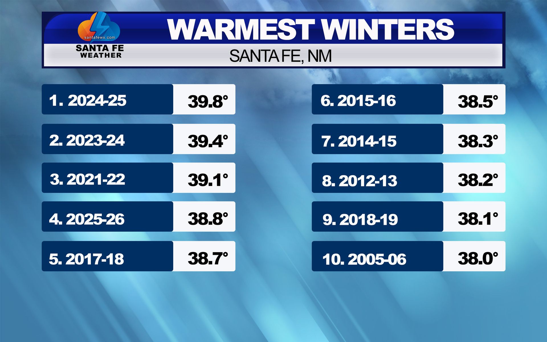
A Winter That Tells a Bigger Story: Santa Fe’s Warmest Seasons and the Climate Signal Behind Them The winter of 2025–2026 finished with an average temperature of 38.8°F, making it the 4th warmest meteorological winter (December through February) ever recorded in Santa Fe. What makes that ranking especially remarkable is that it came despite a a couple of cold snaps in January that temporarily dragged down the seasonal average. Without that stretch of colder weather, this winter likely would have landed among the top three. But the real headline isn’t just where this winter ranked. It’s what the entire top-10 list reveals about how Santa Fe’s winter climate is changing. The Warmest Winters Are No Longer Rare E very one of the 10 warmest winters on record has occurred since 2000, and nine of them have happened since the winter of 2012–2013. That kind of clustering in such a short period is not natural variability — it’s a clear climate signal. For most of the historical record, warm winters were occasional outliers. Now they are becoming the norm. Instead of asking if a winter will be warm enough to challenge the record, we’re increasingly asking how high it will rank. And the most recent winters have been especially notable: #1 – 2024–2025 #2 – 2023–2024 #3 – 2021–2022 #4 – 2025–2026 That means four of the warmest winters ever recorded in Santa Fe have occurred in just the past five years. The Role of January’s Cold Snap This past winter is a perfect example of how the baseline has shifted. Both December and February were the warmest on record in Santa Fe. Yet a couple of colder-than-average stretches in January were enough to keep the season from climbing even higher in the rankings. In a colder climate, a month like that would have defined the winter. In today’s climate, it simply trims the final number slightly. That’s a powerful indication that the background temperature — the baseline — is warmer than it used to be. The Climate Signal in Santa Fe When we talk about a “climate signal,” we’re talking about a long-term shift that rises above year-to-year weather variability. In Santa Fe, that signal is showing up in several clear ways. Warmer average winter temperatures Winters are not just occasionally warm — they are consistently warm compared to the past. Much warmer overnight lows Nighttime temperatures are rising faster than daytime highs. This has a huge impact on monthly and seasonal averages and reduces the frequency of deep freezes. Shorter and less intense cold periods Cold snaps still happen, but: They don’t last as long They are more easily offset by extended warm periods More winter days in the 50s, 60s, and even 70s These would have been unusual in past decades. Now they occur almost every winter. Why This Is Happening Santa Fe sits at over 7,000 feet, so its climate is highly sensitive to temperature changes. A relatively small regional warming signal translates into a big local impact. Several factors are contributing: 1. Long-term warming across the Southwest Average temperatures across New Mexico and the broader Southwest have risen significantly over the past several decades. Winter is one of the fastest-warming seasons. 2. Rising overnight temperatures Higher humidity, fewer prolonged snow-cover periods, and a warmer atmosphere all help keep nighttime temperatures from dropping as low as they once did. 3. Persistent high-pressure patterns In recent years, we’ve seen more frequent winter ridging over the region. That brings: Sunshine Dry air Downslope warming All of which push temperatures above normal. 4. Reduced snow cover Snow reflects sunlight. Without it, the ground absorbs heat, which: Warms afternoons Leads to milder nights This creates a feedback loop that reinforces warm winters. What This Means for Future Winters The most important takeaway is this: This is no longer a short-term trend — it’s a new climate baseline. That doesn’t mean Santa Fe won’t have cold or snowy winters again. We absolutely will. Individual seasons will still vary. But it does mean: Warm winters will occur more often than cold ones Top-10 warmest winters will continue to cluster in the modern era Snowfall will depend more on storm tracks and timing, not just precipitation totals More winter storms will fall as rain at lower elevations The snow season will become shorter on average In other words, the type of winter that once felt unusual is becoming typical. A Shift You Can Feel This isn’t just something that shows up in a spreadsheet. It’s what people across Santa Fe have been noticing: Fewer prolonged cold stretches More mid-winter warm spells Less persistent snow cover in town Earlier signs of spring The data now backs up those observations in a very clear way.

How Accurate Are Extended Weather Forecasts in Santa Fe? One of the most common questions I get is: “How reliable is the forecast a week or more in advance—especially here in Santa Fe?” The short answer is: forecasts are quite accurate in the short term, fairly reliable out to about a week, and increasingly uncertain beyond that. And in a place like Santa Fe, with our complex terrain and microclimates, that uncertainty can grow even faster than in flatter parts of the country. Understanding how forecast accuracy changes over time can help you use the information more effectively. Why Forecasting Is Especially Challenging in Santa Fe Santa Fe sits in a uniquely complex location: We’re about 7,000 feet in elevation We’re surrounded by mountains and valleys We’re influenced by desert, mountain, and plains weather patterns We sit near major climate boundaries Just within the metro area, temperatures, wind, and precipitation can vary dramatically from one neighborhood to another. What happens near the Plaza may be very different from what’s happening near the airport, in Eldorado, or up toward the Ski Basin. Add in the Sangre de Cristo Mountains to our east and north, and suddenly weather systems are being lifted, blocked, redirected, or weakened as they move through the region. All of this makes Santa Fe a fascinating place to forecast—but also a very challenging one. Days 1–3: High Confidence (Even Here) For the next one to three days, forecasts in Santa Fe are usually very reliable. By this point, weather systems are well observed by satellites, radar, weather balloons, and surface stations. Computer models have a strong handle on how fronts, storms, and temperature patterns will interact with our terrain. During this period, you can usually trust: High and low temperatures Snow or rain chances Wind impacts Freeze potential Even with our microclimates, confidence is high in this window. Days 4–7: Good Guidance, But Terrain Matters More From about four to seven days out, forecasts are still useful—but this is where Santa Fe’s geography starts to play a bigger role. At this range: A storm track shifting 50 miles can mean snow for us…or nothing A slight temperature change can affect snow levels Wind direction can determine who gets moisture and who stays dry In flat areas, these small shifts might not matter much. In northern New Mexico, they matter a lot. So while the overall pattern is usually correct, the local details are still coming into focus. Beyond 7 Days: Patterns, Not Promises After about a week, forecast uncertainty increases quickly—especially here. At Days 8–10: Models may disagree on storm placement Mountain effects are harder to predict Moisture sources may strengthen or weaken Cold air may arrive too early, too late, or not at all At this stage, we’re no longer forecasting specific weather events. We’re watching for developing patterns. Why I Still Show a 10-Day Forecast for Santa Fe Even with the uncertainty, I continue to provide a 10-day forecast because it offers valuable early insight. Those last few days often give us clues about: A possible winter storm setup A shift toward warmer or colder weather A developing monsoon pattern in summer Extended dry spells Windy periods For Santa Fe, this is especially important. Many of our biggest weather events—snowstorms, cold outbreaks, heavy monsoon rains—start showing up in the models a week or more in advance. The 10-day forecast helps us spot those early signals. Why Extended Forecasts Often Change Here In Santa Fe, forecasts between 7 and 10 days out change frequently—and that’s normal. Our terrain can: Weaken approaching storms Split precipitation bands Block cold air Enhance snowfall in some areas and suppress it in others A system that looks strong a week out may weaken as it crosses the mountains. A storm that seems too far south may shift north at the last minute. Moisture may dry up before reaching us. As better data becomes available, the forecast sharpens. How to Use Santa Fe’s Extended Forecast Wisely Here’s the best way to think about it: Days 1–3: High confidence Days 4–7: Reliable trends, flexible details Days 8–10: Pattern watching Use the long-range forecast to stay aware of what might be coming. Then rely on frequent updates as we get closer.

What Is a Backdoor Cold Front and Why They Matter in Santa Fe When most people think of a cold front, they picture colder air sweeping in from the west or northwest, often behind a Pacific storm system. In New Mexico, however, some of our most noticeable and sometimes frustrating weather changes arrive from the opposite direction. These are known as backdoor cold fronts, and they play an outsized role in Santa Fe’s weather. What Exactly Is a Backdoor Cold Front? A backdoor cold front is a shallow surge of cold air that moves west or southwest into New Mexico from the Great Plains, rather than the typical west-to-east progression. These fronts often originate when strong high pressure builds over the central or northern Plains, allowing cold, dense air to spill south and west through gaps in the terrain. Instead of coming “through the front door” from the Pacific, the cold air sneaks in through the “back door” — often sliding down the eastern slopes of the Rocky Mountains and pushing into eastern and central New Mexico. Why New Mexico Is Prone to Backdoor Fronts New Mexico’s geography makes it especially vulnerable to these events: Cold air is dense and shallow, allowing it to hug the ground and flow through mountain passes and river valleys. The Great Plains to our east provide a direct source of continental polar air, especially in fall, winter, and early spring. Once established, high pressure east of the state can continuously feed cooler air westward for days. Because these fronts are shallow, they often undercut warmer air aloft, leading to cloudy, chilly conditions at the surface while temperatures just a few thousand feet above the ground remain relatively mild. How Backdoor Cold Fronts Impact Santa Fe Santa Fe is particularly sensitive to backdoor cold fronts due to its elevation and location near the Sangre de Cristo Mountains. Here’s what typically happens when one arrives: 1. Sudden Temperature Drops Temperatures in Santa Fe can fall 10–25 degrees in just a few hours, especially during the afternoon or evening when daytime heating is abruptly cut off. A day that starts mild can end feeling wintry. 2. Persistent Cold and Clouds Because the cold air is shallow and trapped against the east slopes of the mountains, it can be slow to scour out. This often leads to: Low clouds Overcast skies Drizzle, mist, or light freezing precipitation in colder months These cloudy, cold conditions can linger for several days, even while areas west of the mountains warm up. 3. Upslope Moisture and Light Precipitation As easterly or northeasterly winds push moist air upslope into the Sangre de Cristos, areas just east of Santa Fe can see: Light rain or drizzle Light snow or freezing drizzle in winter Patchy fog, especially overnight and early morning These events usually don’t produce heavy precipitation in Santa Fe alone, but they can create slick roads and travel issues, especially along I-25 and through mountain passes. When combined with an upper level low or another storm system with great timing, they can lead to a winter storm in Santa Fe. 4. Sharp Microclimate Differences One hallmark of a backdoor front is dramatic temperature contrasts: Santa Fe may be stuck in the 30s or 40s with clouds Albuquerque could be warmer or sunnier and impacted by strong winds Western New Mexico may remain mild and dry This makes forecasting tricky and explains why Santa Fe’s weather can feel out of sync with areas just to our west. When Are Backdoor Cold Fronts Most Common? Backdoor cold fronts can occur any time of year, but they are most frequent and impactful during: Late fall Winter Early spring In summer, weaker versions can sometimes bring brief cooling and upslope thunderstorms, but they are generally less dramatic than their cold-season counterparts. Why They’re So Important for Forecasting Santa Fe Weather For Santa Fe, backdoor cold fronts often determine: Whether temperatures stay mild or turn sharply colder How long clouds linger Whether precipitation falls as rain, snow, or freezing drizzle Overnight low temperatures and frost potential They are also one of the main reasons long-range forecasts for Santa Fe can change quickly, especially when strong high pressure develops east of the Rockies. The Bottom Line Backdoor cold fronts are a defining feature of Northern New Mexico weather, and the eastern half of New Mexico feels their effects more than most places in the state. While they rarely bring major storms, they can dramatically change temperatures, cloud cover, and travel conditions — sometimes very quickly. Understanding these fronts helps explain why Santa Fe can go from sunny and mild to cold and gray in a matter of hours, even when the forecast elsewhere looks quiet.

Top 10 Santa Fe Weather Events of 2025 From record warmth to powerful winds — and even a blast of true Arctic cold — 2025 was a year of weather extremes in Santa Fe. While we didn’t see a classic snowy winter, the atmosphere made up for it in other ways, delivering memorable moments that shaped our year and impacted daily life across northern New Mexico. Each of these events tells a bigger story about the patterns that drove our weather in 2025 — from persistent warmth and dryness to brief but intense departures from the norm. Here’s a look back at the Top 10 Santa Fe Weather Events of 2025, and what they reveal about the year that was. #10 Santa Fe's Coldest Day of Year The coldest temperature of 2025 in Santa Fe occurred on January 21, when the temperature dropped to -6°. This bitter cold was caused by a true Arctic air mass that plunged south out of Canada and spread across much of the central United States. Unlike typical winter cold fronts, this air mass was exceptionally dense and shallow, allowing it to funnel south through the Plains and into New Mexico. Once it reached Santa Fe, clear skies, light winds, and fresh cold air allowed temperatures to drop sharply overnight. This was not just a local event — the cold air covered a large portion of the country, bringing subzero temperatures and dangerous wind chills from the northern Plains all the way into the Southwest. It was one of the coldest and most widespread cold outbreaks of the winter, and a reminder of what true Arctic air can still deliver, even during otherwise mild winters. #9 Drought After coming off of a very dry winter, the spring started with Extreme Drought in Santa Fe. In April, extreme drought extended throughout the northern mountains. However, some much needed and unusual spring rains came in May and June which erased the drought in Eastern New Mexico. Drought conditions still persisted in Santa Fe, but the rains helped tremendously and reduced the fire risk. #8 Monsoon Season Thanks to a wet June and September and near normal rainfall in August, the monsoon season finished with a little more than an inch above normal. The summer certainly had some notable dry stretches, but heavy rains made up for the dry periods. The rainfall was spotty however, as monsoon moisture often can be. Albuquerque was much below normal for the monsoon season. #7 Lack of Snow On average, Santa Fe picks up about 22 inches of snow each winter, and when you look at the entire 2024–2025 season, we actually came fairly close to that number. But the story behind it matters. Nearly 15 inches fell in a single storm in November 2024, doing most of the heavy lifting for the season. After that, snowfall was sparse. When you narrow it down to calendar year 2025, the lack of snow really stands out: • 7.9 inches fell between January and April • 2.1 inches fell in early December That puts total snowfall for 2025 at just 10 inches — well below what we’d typically expect in a normal year. #6 Summer Heat For the third year in a row, Santa Fe made it into the top 4 years for the number of 90-degree days in a summer. In 2025, we hit 90 or above 45 times. All of this occurred June, July, and August. Each month we hit 90-degrees 15 times. #5 100° in Santa Fe Santa Fe reached 100° on July 10, making it just the third time the city has officially hit triple digits—and all three have happened this decade. The all-time record high for Santa Fe is 102°, set on June 14, 2021. The city then hit 100° on July 18, 2023, before doing it again this year. A quick note on the data: you may see slightly different numbers from the National Weather Service. There’s a 40-year gap (1958–1998) in the official record, so for long-term analysis I use a dataset that includes continuous records back to 1874. Since 2021, these temperature observations have been taken at the Santa Fe airport, which is typically warmer than much of the city. That shift in observation location helps explain why Santa Fe didn’t officially record 100° days until recently. So yes—climate change is warming the planet, but elevation and location also play a role. #4 La Niña Development La Niña, the cooling of Pacific waters near the equator and the opposite of El Niño, typically brings warmer temperatures and drier conditions to New Mexico. That’s exactly what we’ve seen so far this winter in Santa Fe. This is a weak La Niña, though, and forecasts still point to a possible shift toward ENSO-neutral conditions late this winter or early spring. If that transition happens in time, we could see a more active second half of the season. That said, it’s now looking likely we’ll finish the winter below our normal ~22 inches of snowfall. #3 Record Warm December We’re not quite done with the month yet, but so far December 2025 is on track to be the warmest December ever recorded in Santa Fe. The La Niña pattern didn’t just bring above-normal temperatures, it delivered 10 days of record-highs at the Santa Fe Airport including the warmest Christmas Eve and Christmas Day. #2 Spring Winds New Mexico is no stranger to spring wind, but 2025 took it to another level. Santa Fe experienced an unusually high number of windy days, with wind gusts topping 60 mph on multiple occasions. Those strong winds followed an extremely dry winter, kicking up dust and leading to dangerous dust storms across the state. At least one major event caused a multi-vehicle pileup on I-25 south of Santa Fe, while in southern New Mexico, I-10 near Deming was closed several times due to near-zero visibility and crashes. It was a stark reminder that in New Mexico, wind can be just as impactful, and dangerous, as snow or storms. #1 Record May Rainfall After a very dry winter and an even drier start to spring, early May delivered a remarkable turnaround. From May 4–6, Santa Fe was hit with several days of heavy rain — an unusual event for a time of year that’s typically one of our driest. In just those three days, Santa Fe picked up roughly a quarter of our average annual rainfall. While the airport officially measured 1.65 inches, much of the city saw over 3 inches, especially near the foothills on the east side. The intense rainfall led to flooding in homes and businesses, highlighting how vulnerable Santa Fe can be when heavy rain falls over a short period of time. That May event, combined with another significant rain in June, ultimately pushed 2025’s annual rainfall above normal. Without those two storms, the year would have ended well below average. A powerful reminder that in Santa Fe, just a few well-timed storms can completely change the story of an entire year.
Why Has It Been So Warm in Santa Fe - and Will it Last? If you’ve been enjoying the mild afternoons lately, you’re not imagining things. Santa Fe has been running unseasonably warm for much of December, with daytime highs frequently climbing well above normal and very little in the way of cold air or snow. It’s a pattern that has raised plenty of questions — especially with Christmas just around the corner. So what’s going on, and should we expect a change anytime soon? A Classic La Niña Pattern The warmth we’re experiencing is very typical of a La Niña winter, particularly early in the season. During La Niña, cooler-than-normal waters in the equatorial Pacific tend to shift the jet stream farther north. For New Mexico, that often means: Fewer storms tracking through the Southwest More frequent ridging (high pressure) over the region Warmer daytime temperatures Longer dry stretches between storms In Santa Fe, La Niña winters often start slow, especially when it comes to snowfall. Cold air struggles to push this far south, and storm systems that might normally bring snow either weaken or pass well to our north. Will This Warm Pattern Last Through Christmas? This is the question I’m hearing most right now — and based on current data, yes, the pattern looks likely to hold through Christmas and probably through the end of the year. Forecast models continue to show persistent high pressure nearby, limited storm activity, and temperatures staying above normal for late December. That doesn’t mean we can’t sneak in a brief cool-down or a weak system, but at this point it does mean there’s no clear signal for a sustained cold or snowy pattern before the calendar flips to January. In other words, if you’re hoping for a white Christmas in Santa Fe, the odds aren’t looking great this year. Mild afternoons, chilly nights, and generally dry conditions remain the most likely outcome through the holiday period. Does That Mean the Rest of Winter Is a Bust? Not necessarily — and this is where things get more interesting. While La Niña is currently influencing our weather, longer-range climate guidance continues to suggest that this event may weaken as we move deeper into winter. Several climate models are still pointing toward a transition out of La Niña and into an ENSO-neutral pattern later in the season. That matters because ENSO-neutral winters can open the door to a very different setup for New Mexico. What Happens If We Shift to ENSO Neutral? If La Niña fades and we move into neutral conditions, the jet stream often becomes more variable and less locked into one position. For Santa Fe, that can mean: More frequent storm systems reaching the Southwest Better opportunities for colder air to move south An increased chance for snow-producing systems More active weather during the second half of winter Historically, some of our better snow seasons in northern New Mexico have featured slow starts followed by a more active late winter. February and even early March can end up doing a lot of the heavy lifting when it comes to seasonal snowfall totals. The Bottom Line The recent warmth is not unusual for a La Niña winter, especially in December Current trends suggest mild and mostly dry weather through Christmas and the end of the year There are credible signs that La Niña may weaken later this winter If we transition to ENSO-neutral conditions, colder and potentially snowier weather could arrive during the second half of winter So while it may feel more like fall or spring than winter right now, winter isn’t over by a long shot (technically, it hasn't even started). Santa Fe winters have a habit of saving some surprises for later — and I’ll be watching closely to see if that late-season pattern shift begins to show up in the weeks ahead. Stay tuned.
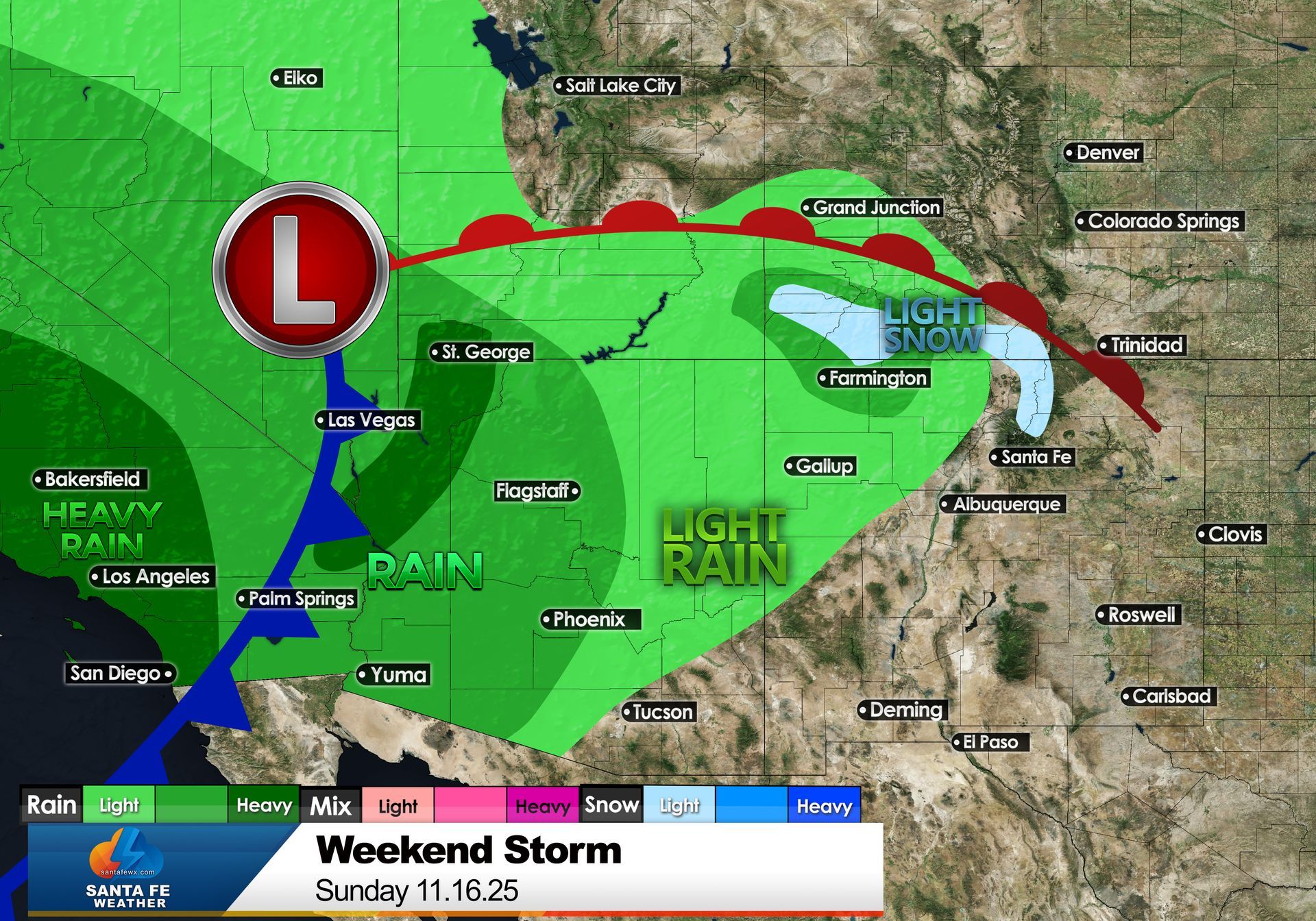
Updated Storm Track for Weekend Storm November 14, 2025 By Jay Faught The storm system we’ve been watching all week has shifted—but this time, it’s slowing down and taking a more northerly route. That updated path dramatically changes the weekend forecast for Santa Fe and northern New Mexico. A Slower, More Northern Storm Track Earlier projections had the storm sweeping into New Mexico sooner, with a more organized band of moisture. But the latest data shows the system digging more slowly along the West Coast and pushing a bit farther north than originally expected. That shift means Southern California will now take the brunt of the storm, with periods of heavy rain and even flooding concerns in some areas. For us in Santa Fe, however, the impacts will be much more limited. Santa Fe’s Updated Forecast: Light and Late Instead of showers developing Saturday or early Sunday, the latest timing suggests isolated light rain showers won’t arrive until Sunday night. The moisture feed simply doesn’t extend far enough south to bring widespread precipitation to our area. Here’s what that means for your weekend plans: Most of the weekend stays dry—great news if you're planning outdoor activities around town or on the trails. Isolated showers Sunday night may bring brief dampness but nothing widespread or soaking. Snow Levels: Staying High There will be just enough moisture and lift Sunday night into early Monday for a few flakes in the higher terrain: Light snow is possible above 9,000 feet, mainly over the highest peaks of the Sangre de Cristo Mountains. Accumulations look minimal, and ski areas won’t see major impacts, though the first hints of winter are always exciting. Valleys, including Santa Fe, will stay warm enough for just light rain if anything at all. Bottom Line While this storm is impressive for the West Coast, its slower and more northern track means Santa Fe will see only minor impacts—mostly a few isolated showers Sunday night and perhaps a dusting of snow high in the mountains. A bigger takeaway: this pattern shift still hints at an active atmosphere as we move deeper into November. It’s a good reminder that our storm season is just getting started.

The Albuquerque International Balloon Fiesta may look magical, but every launch depends on one thing: the wind.